Those attracted to the 'sport of kings' may get no further than the car park, which overlooks an extensive gallops, where racehorses can often be seen being put through their paces in the early morning. But stride on, for there is much more to see along the way, in earthworks, tumuli and
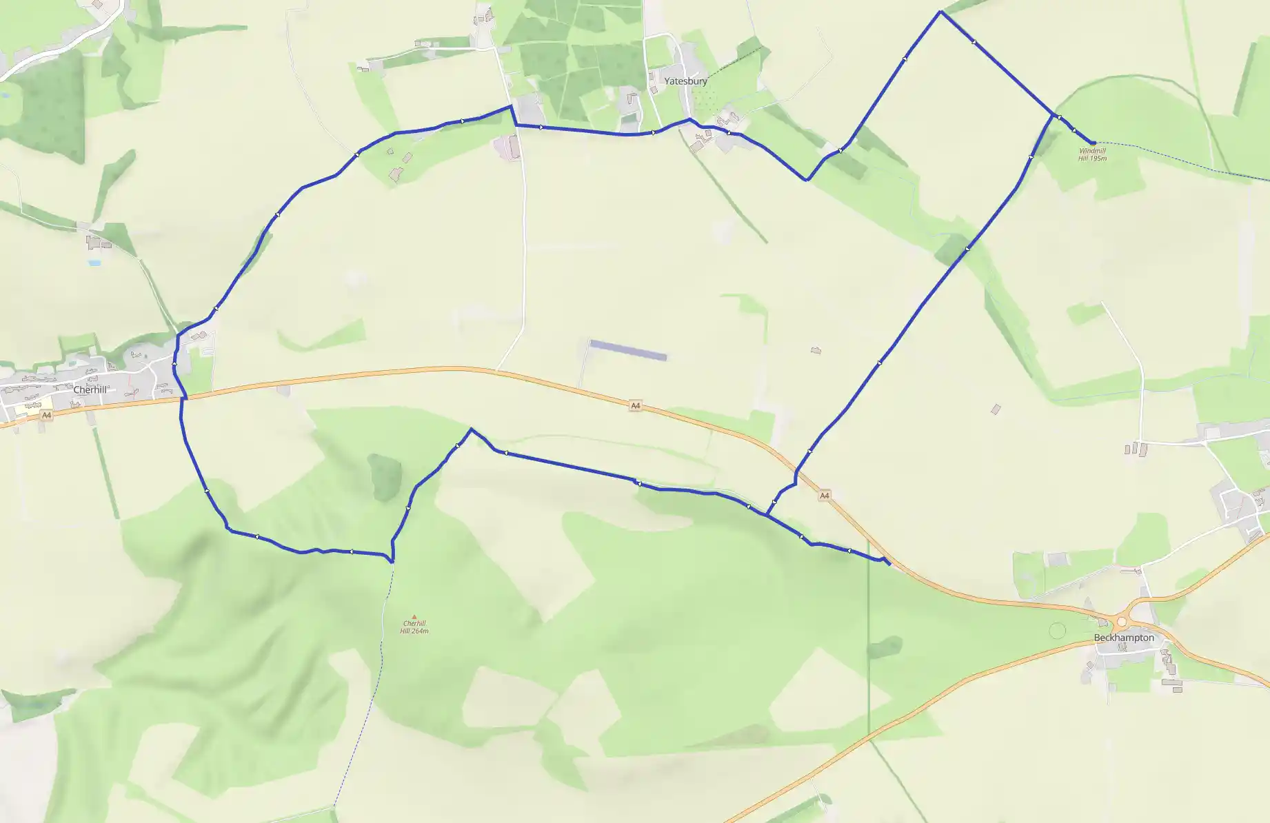
Cherhill White Horse and Windmill Hill
April 17, 2026
by  @robertclarke64@wanderer.robertclarke.co.uk
Beckhampton, England, United Kingdom
Moderate
Not completed
Distance 14.48 km
Est. duration 02h 59m
Elevation Gain 230 m
Elevation Loss 233 m
Category Hiking
Description
Route
Start
Start
51.42206, -1.89139Begin through a bridle gate at the far end of the lay-by. Take the left branch of parallel paths that climb onto Knoll Down, from where there is a view across to the Lansdowne Monument on Cherhill Hill. Ignore a path coming in from the right and carry on ahead along the line of the Old Bath Road. Later on, the path and a parallel bridleway combine, passing a tumulus to reach a T-junction.
1.43 km
51.42812, -1.92187
Turn left, climbing to a barn and small covered reservoir. Where the track then splits, keep right through a gate and continue climbing onto Cherhill Down, eventually reaching a junction by the eastern entrance of Oldbury Castle.
1.93 km
51.42223, -1.92767
Go right, winding through the defensive gateway and continuing to the Lansdowne Monument at the far side of the earthwork-enclosed area. Pass on the left, the path then descending. Keep left at a fork down to a gate, and then branch off right on a path to the top of a satellite summit, from which there is a view out right to the Cherhill White Horse. Drop down on the other side to gates at the bottom. Ignore the first gate on the right and carry on round the corner of the fence to a second. Turn through that and go left along a sunken path leading off the hill to the main road at the edge of the village of Cherhill.
2.78 km
Cherhill Hill
51.42832, -1.94077Looking back from the main road, it is possible to see all three of the historic monuments on Cherhill Hill. Perhaps the most prominent, and a landmark for miles around, is the Lansdowne Monument, a 125-foot (38-m) high obelisk erected in 1845 by the third Marquis of Lansdowne to celebrate his great-great-grandfather, Sir William Petty. Petty had a wide ranging interest that covered medicine, surveying, politics, economics, philosophy and science, and was a member of the Royal Society. The Cherhill White Horse, high on the slope to the east was cut in 1780 under the direction of Dr Christopher Alsop, coincidentally a friend of the Liverpool artist George Stubbs who specialised in painting animals, particularly horses. The third of the hill's monuments is the impressive Oldbury Castle, an extensive bivallate (double bank and ditch) Iron Age fort. It was occupied from around 500вc until the arrival of the Romans and surrounded an earlier enclosure settled towards the end of the Bronze Age.
2.92 km
51.42955, -1.94292
The Black Horse lies a little over ¼ mile (400m) to the left, but the onward route lies along Park Lane opposite. Climb up at the edge of the village, past a junction with The Street, but branch off right beyond along a signed byway. After later passing a bridleway joining from the left, watch for a wartime pillbox in the field on the right. Farther on, largely hidden by trees are the surviving buildings of the West Camp of RAF Yatesbury. Carry on until you meet a lane at the end of the track.
4.32 km
RAF Yatesbury
51.43719, -1.92116Established in 1916, the airfield at Yatesbury was used to train pilots for the Roal Flying Corps, which had both army and naval wings. It was not until 1918 that the two were combined to form the RAF. In 1920 the base closed, but with the threat of war in Europe emerging again in the 1930s, it reopened, initially training pilots but later focusing on radio and radar training, an activity that continue during the Cold War era of the 1950s. The base finally closed in 1965.
4.48 km
51.44285, -1.91905
Turn right to a junction and then left along The Avenue. Farther on, a lane off left leads to All Saints' Church where there are a number of War Graves containing personnel who died while serving at RAF Yatesbury. Return and walk on along the main lane to a junction by a bus shelter.
5.09 km
51.44226, -1.90594
Go right to Yatesbury House Farm and continue past Little London on a track. Soon reaching a junction, turn left to pass through Snake's Lane Plantation and on to the top of a shallow hill where there are several gates.
6.20 km
51.44715, -1.88766
Take the bridle gate on the right and follow a path through a long belt of trees. Emerging at the far end onto a crossing track, the gate opposite opens onto Windmill Hill; climb onto the top for the views.
6.86 km
51.44131, -1.87630
Return to the main track and go left. Follow it ahead for almost 1½ miles (2.4km) to reach the A4.
8.41 km
51.42633, -1.89798
Cross to the track opposite, which winds through a clump of trees and climbs onto Knoll Down. Meeting a crossing path at the top, go left, reversing your outward route, but this time, take the left branch which wanders through a small beech wood on its way back to the car park.
14.48 km
Finish