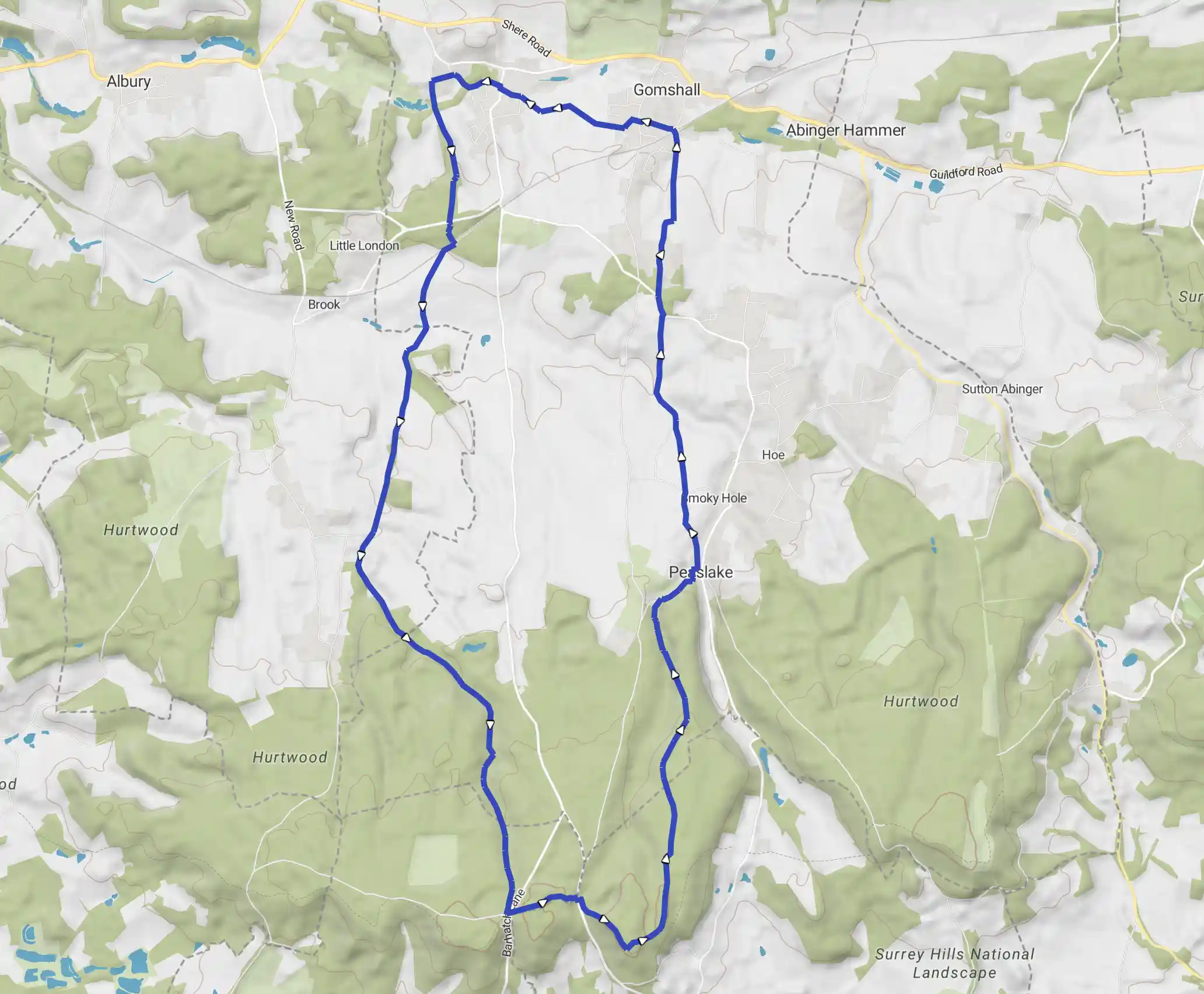
Shere and Hurt Wood
May 16, 2025
Waverley, England, United Kingdom
Moderate
Not completed
Description
Route
Start
Start
51.17206, -0.46423With your back to the car park turn right to the T-junction and cross the road to the public footpath sign 'Greensand Way'. Follow the waymarkers, turning right alongside the fence to Four Winds house, down to reach the road beside Mill Cottage. Cross the road and turn right to continue along the Greensand Way as it climbs past a quarry pit to the triangulation pillar at the top of Pitch Hill.
609 m
The views from here are among the finest in Surrey and on a clear day you can see over the Weald of Surrey as far as the English Channel. Follow the Greensand Way as it runs beside wooden hand rails and then as it broadens among the trees. At the next waymarked post, instead of turning right downhill, keep ahead leaving the Greensand Way to reach a broad crossway.
1.15 km
Keep ahead along this wide, sandy bridleway and follow it through Hurt Wood, bearing left to descend at a fork. With more than 60 miles (96km) of access tracks the Hurt Wood on the Greensand Ridge is the largest area of commonland in Surrey. In 1926 it was one of the first privately owned areas in the country to adopt a 'right to roam' and features a great many Scots Pine trees, planted here in the 18th century. At a T-junction turn right and continue past a car park (no. 2) to the road.
2.16 km
Turn right C, and follow the roadside path on the right as it ascends to a tarmac road. Bear left, passing to the right of Peaslake church and at the road turn right and then left at the Hurtwood Inn into Pond Lane. At the fork with Burchetts Hollow go through the kissing-gate opposite, beside a public footpath sign, and cross the field to Jesses Lane. Turn right, at the next T-junction turn left, and after 100 yards turn right into Birches Lane.
3.52 km
Continue along the waymarked footpath to the left as it initially passes houses and later becomes enclosed. After the path curves right, turn left to join a bridleway. Keep ahead along this leafy tunnel to a road and pass under a railway bridge.
4.21 km
Turn left along High View and at the road junction, cross over and continue along Gravelpits Lane. At the fork beside Gravelpits Farmhouse turn right along the bridleway and over to the right is Netley Park. Soon the spire of Shere church comes into view ahead. Where the enclosed path ends continue across the right-hand field edge and at a path junction turn right to pass beside the church and a row of shops to a road. Opposite is the White Horse pub and to the left, The William Bray. Shere is a popular location for filming and the church and adjacent row of shops were featured in the pilot episode of the TV series, Foyle's War. Turn right and just before the bridge turn left and follow a path beside the Tilling Bourne stream that passes a row of cottages and the tidy village allotments before curving right. Cross the wooden footbridge beside the ford and keep ahead to continue along 'The Foxway' footpath to the right of The Old Rectory.
5.29 km
At the lane turn left, and cross Chantry footbridge over the Tilling Bourne. Keep ahead along a shady bridleway that runs to the left of a garden fence. At a fork with a central waymarker, turn right and look out for where you turn left 40 yards farther, along an uphill bridleway through Shere Heath. Cross a road and at a T-junction turn left and go over the railway crossing with care. Turn right and follow the track (Ponds Lane), which is sometimes deeply rutted, for about 1½ miles (2.4km). Just after the path passes the entrance to Lockhurst Hatch Farm turn left at a bridleway sign along a narrow track.
7.22 km
At a fork bear left past a house and follow the blue waymarkers along this delightful, leafy bridleway. At the next waymarked fork turn right and continue along the valley of Winterfold Wood. Much of this is privately owned and part of the Hurt Wood area of the North Downs. Apparently, some of the proceeds of the Great Train robbery were also buried here. At the 4-way path junction turn right.
8.34 km
Cross a track, bear left at the next fork and maintain direction steadily uphill to return to the car park at the start of the walk.
14.49 km
Finish