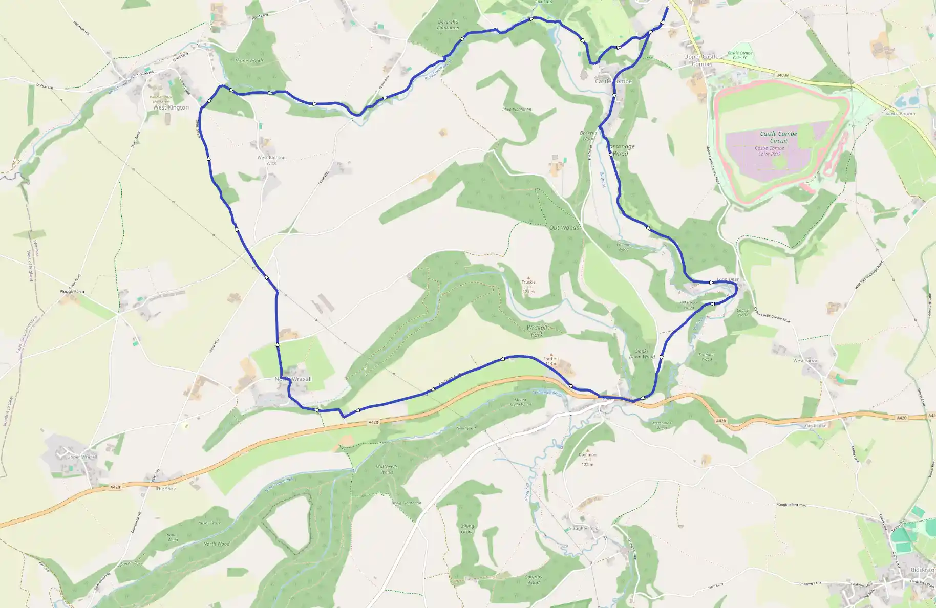
Castle Combe
May 16, 2025
Upper Castle Combe, England, United Kingdom
Moderate
Not completed
Description
Route
Start
14 m
Start
51.49806, -2.22343Leave the car park and follow the lane towards the lower village. Bear right at a junction and continue downhill to the square and covered market cross at the old heart of Castle Combe. Bear left through the village, shortly crossing a bridge over By Brook. Keep going, now beside the stream. Carry on past a private bridge giving access to Brook House to reach a second bridge, just a little farther along.
665 m
A
51.49032, -2.23047Abandon the lane there, crossing the stream onto a clear path that rises to contour the sloping meadows and trees of the valley side. Eventually entering woodland, ignore a waymarked path off right and remain with the ongoing track. Farther on, beyond a couple of consecutive gates, the trail eventually breaks from the trees to drop past Upper Long Dean Mill, where it becomes a lane.
1.76 km
B
51.48002, -2.21620As the lane swings left, bear off right and then fork right to remain with the bridleway. Carry on over a bridge and past a house, the track now climbing along a narrow wooded ridge. Through a gate at the top, the way leaves the trees to run above a sloping meadow from which there is a fine view along the valley. Where the contained bridleway shortly bends right, pass through a kissing-gate and follow a trod across the meadow towards trees at the far side.
2.34 km
C
51.47423, -2.22443Emerge through a final kissing-gate onto a lane and turn downhill to reach the main road at the bottom. Go right for 250 yards, passing the slender wooden spire of St John's Church to then immediately turn off up a narrow Jane, the Old Coach Road. It is a bit of a climb to the top, but beyond New Church Farm the gradient cases and the way continues as a pleasant track above the Doncombe Valley.
3.97 km
D
51.47135, -2.25737Mecting a lane at the far end, walk right and follow it steeply down into a valley and up the other side into North Wraxall. Towards the top, keep left past the church and go right at the junction just beyond. The lane rises over the crest of the hill past Court Close Farm, shortly passing beneath pylon cables. Immediately, turn off over a stile on the left and bear right across a field to a gate and stile on the opposite side.
4.77 km
E
51.47954, -2.26441There, emerging onto a narrow lane, cross to the gate opposite. Go right and left within the field corner, walking on a further few yards to find a stile on the right. Turn left in the adjacent field and head down into a deep dip before climbing to a stile in the top fence out onto another narrow lane. Cross to the field opposite and stride on with a wall on your left. After 200 yards, slip through a gap and continue on the opposite side of the boundary. Keep going at the edge of successive fields, the way developing as a track and ultimately joining the end of a lane at the edge of West Kington. As the lane then bends left past houses, keep ahead on a marked bridleway next to the end cottage garden. Ignore a crossing track and carry on beside a field before dropping out at the bottom onto a lane.
5.85 km
F
51.49303, -2.27008Go right above Parsonage Wood. After 150 yards, reaching the end of a wall, branch off left on a bridleway. Wind down to cross Broadmead Brook and head downstream on the opposite bank. Beyond a couple of small meadows, the way continues as a track across the slope of a grass bank. Where it later curves up to a gate, bear off to stay with the lower meadow. At the far end, bend left in front of a gate to exit through a second gate just beyond onto a lane. Follow it left up the hill. As the gradient eases, look for a path departing through a bridle gate on the right.
6.57 km
G
51.49165, -2.25504The trail drops through trees and serub, breaking out to continue along the valley. The way remains clear, alternating between meadows and woodland and passing through occasional gates before eventually falling to the stream by a ford and clapper bridge. However, remain on this bank, but as the path then turns from the stream, abandon it through a gate on the right. Carry on along the wooded valley, in time emerging onto at track at Nettleton Mill.
7.32 km
H
51.49659, -2.24117Go right to find a path leaving through a kissing-gate in the high wall at the end. Wind across the brook and continue downstream through woodland. Before long, the path approaches Manor House Golf Course, and there is a bell beside the path for you to warn golfers of your presence. Keeping a wary eye open for flying golf balls, walk out onto the course and follow a tarmac path to the right, shortly re-crossing the stream on an elegant stone bridge. Immediately, turn off right, but after only a few yards, bear left through rough grass and scrub on a path rising gently along the valley side. After passing into trees, it runs in front of a wall to a gate, from which a path drops into the old village centre. However, the way back is to the left, climbing on beside the wall. Emerging from the trees, walk on briefly at the edge of another section of the golf course before curving away right into scrub. The way continues beside a paddock and then comes out onto a drive. Walk ahead past cottages to meet a lane and follow it up left, branching left again at a junction to return to the car park.
13.44 km
Finish