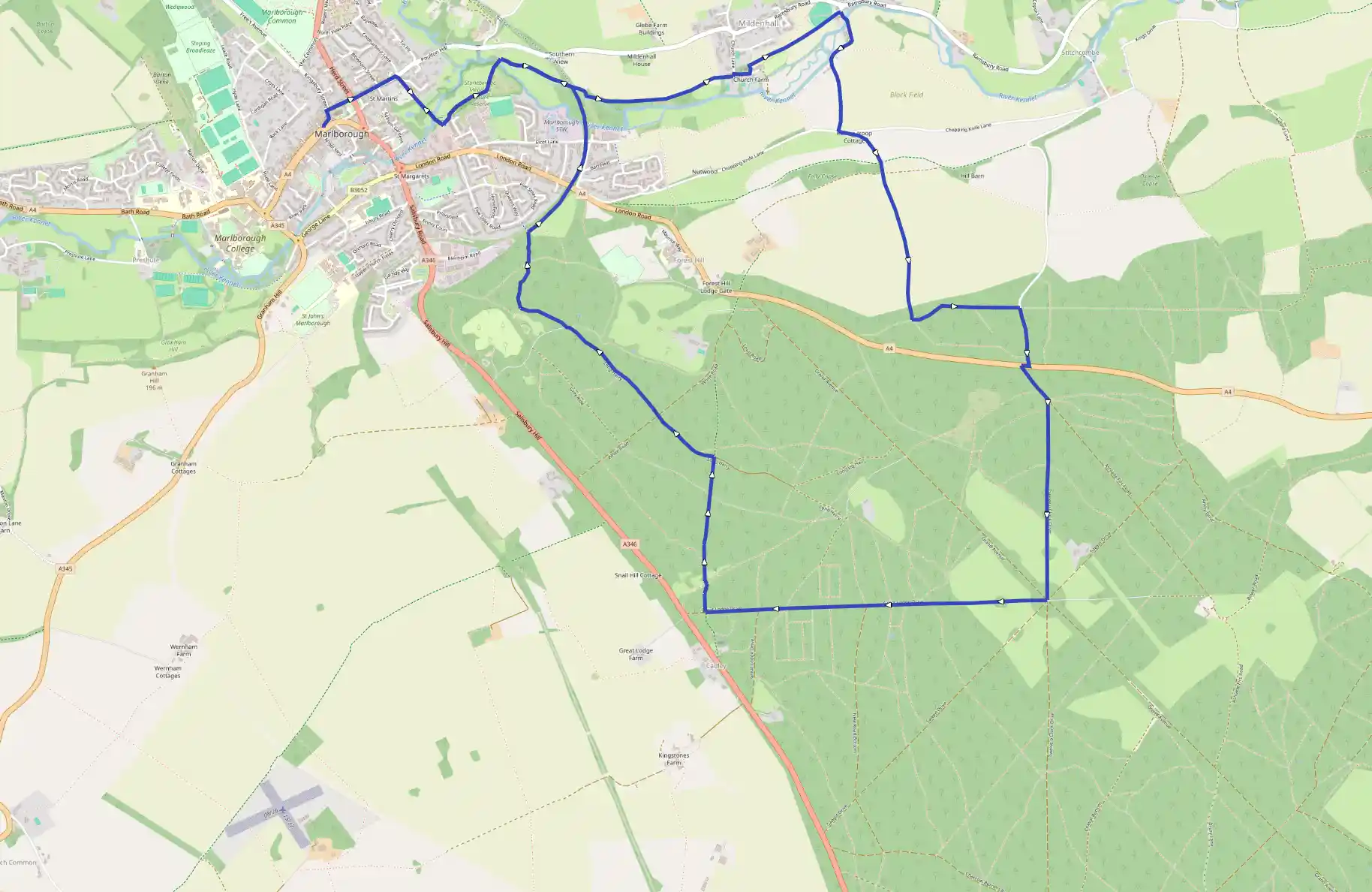
Savernake Forest
May 16, 2025
Marlborough, England, United Kingdom
Easy
Not completed
Description
Route
Start
1 m
Start
51.42128, -1.73032The walk starts at the east end of the High Street in front of the Town Hall, which was built between 1900 and 1902 on the site of its predecessor. Pass to the left of the Town Hall and follow the road to the left, then take the first turning on the right (Silverless Street). Keep ahead at a crossroads by The Green, site of the original Saxon settlement of Marlborough, and continue along the road for 270 yards turning right after a row of houses into Stonebridge Lane.
315 m
Follow this path downhill and cross the footbridge over the River Kennet. Turn sharp left onto a path and continue as it meanders through fields before veering left at a fork. Cross the river again by a wooden footbridge and turn right to pick up a footpath through the field. Head across to the right-hand corner of the field and go through a metal gate into woodland, climb a stile, ascend steps, cross a disused railway track and descend steps on the other side.
1.07 km
Follow the path along the right edge of a field, and at a corner turn right on to a track. The track soon curves left and continues along the right edge of fields. Go through a kissing-gate just to the left of a field corner, at a public footpath sign and continue along a track between farm buildings. Turn left on to a tarmac drive, immediately turn right and after a few yards turn left up steps and go through a lychgate into Mildenhall (shortened locally to Minal) churchyard. Pass to the right of the church, a most attractive and interesting building which retains an impressive Norman nave and was extensively remodelled in the Georgian period. Follow the path to the left and bear right to go through two kissing-gates in quick succession. Walk across a field, keeping parallel to a wire fence on the right, go through a gate, and then keep over to the right-hand side of the field alongside a fence. Go through a metal gate, walk along the right edge of a cricket field and in the corner keep ahead along an enclosed path to a lane.
2.03 km
Turn right, cross the River Kennet, then follow the narrow lane round right-and left-hand bends and head up to a T-junction. Turn left and at a fork ahead, take the right-hand, tarmac drive.
2.45 km
After passing in front of a bungalow, the drive becomes a rough track which heads uphill through trees. Cross a track, continue up to cross another and take the narrow, tree-lined path ahead (Cock-a-troop Lane) - this may be overgrown in places - then enter Savernake Forest. Originally a royal forest, in the 16th century Savernake passed into the ownership of the powerful Seymour family - it was here that Henry VIII courted his third wife, Jane Seymour - and at the end of the 17th century passed to the Bruces, later earls of Ailesbury. It is still owned by that family, but most of it is leased to the Forestry Commission. Savernake is noted for its avenues, particularly the Grand Avenue, a great beech-lined drive planted by the third Earl of Ailesbury in the 18th century. Keep ahead to a public footpath sign and turn left along a track.
3.14 km
Pass beside a barrier and continue through a beautiful stretch of woodland, descending slightly to a lane. Turn right along it to the A4, turn right and after a few yards turn sharp left along a straight forest track.
3.71 km
Go down the slope, pass a circular parking-and-turning area on the right under some beech trees and after about 30 yards, veer half right at a barrier, following a straight track up a gentle slope. Pass through extensive woodland to reach fields bordering the track. Continue ahead to a barrier beyond which is the junction for Eight Walks.
4.47 km
Take the second right exit (no through road) and where it bends left after nearly 1 mile (1.6km), keep ahead along a rough track. About 100 yards before reaching a road, keep a sharp lookout for a right turn into the woods.
5.55 km
Descend gently along the woodland path (Church Walk). At the bottom keep right at a fork, very briefly, before bearing left across an open grassy area to pass round the right-hand edge of a sizeable fallen tree, winding round to the left and then to the right on a track that becomes gradually more established as it passes through woodland. Keep ahead on a broad grassy path, continue ahead at the first crossroads and descend to a junction with a track.
6.04 km
Here turn left and follow the track (Long Harry) through the trees, eventually reaching a track and then a barrier immediately beyond it. Continue to Postern Hill picnic site and when the track bends left just beyond a sign Barbecue Hearth - bookable area, take the right-hand fork. Pass a sign 'Site 6' and then bend right at the next junction. Keep along the right edge of an open area of grassland, follow it round to the right by a sign for Site 3 and follow the broad path through trees. Cross over a path and descend with views of Marlborough to reach the former Chisledon and Marlborough railway, now a designated walking and cycling route.
7.09 km
Turn right. Walk along the hedge-lined track which, after passing under a bridge, curves gradually left. The next section is beautifully tree-lined and there is a dramatic view as you cross a bridge high above the River Kennet. Continue through woodland and look out for wooden rails and steps on both sides of the track.
7.61 km
Here turn left down the steps, rejoining the outward route, and retrace your steps into Marlborough and the starting point of the walk.
13.97 km
Finish