There are some excellent views - and plenty of stiles - along this walk which covers a mix of farms, woodland and heath beneath the North Downs escarpment. After a gradual ascent to Abinger Roughs the route crosses the Tilling Bourne and then climbs once more. There are some splendid views across
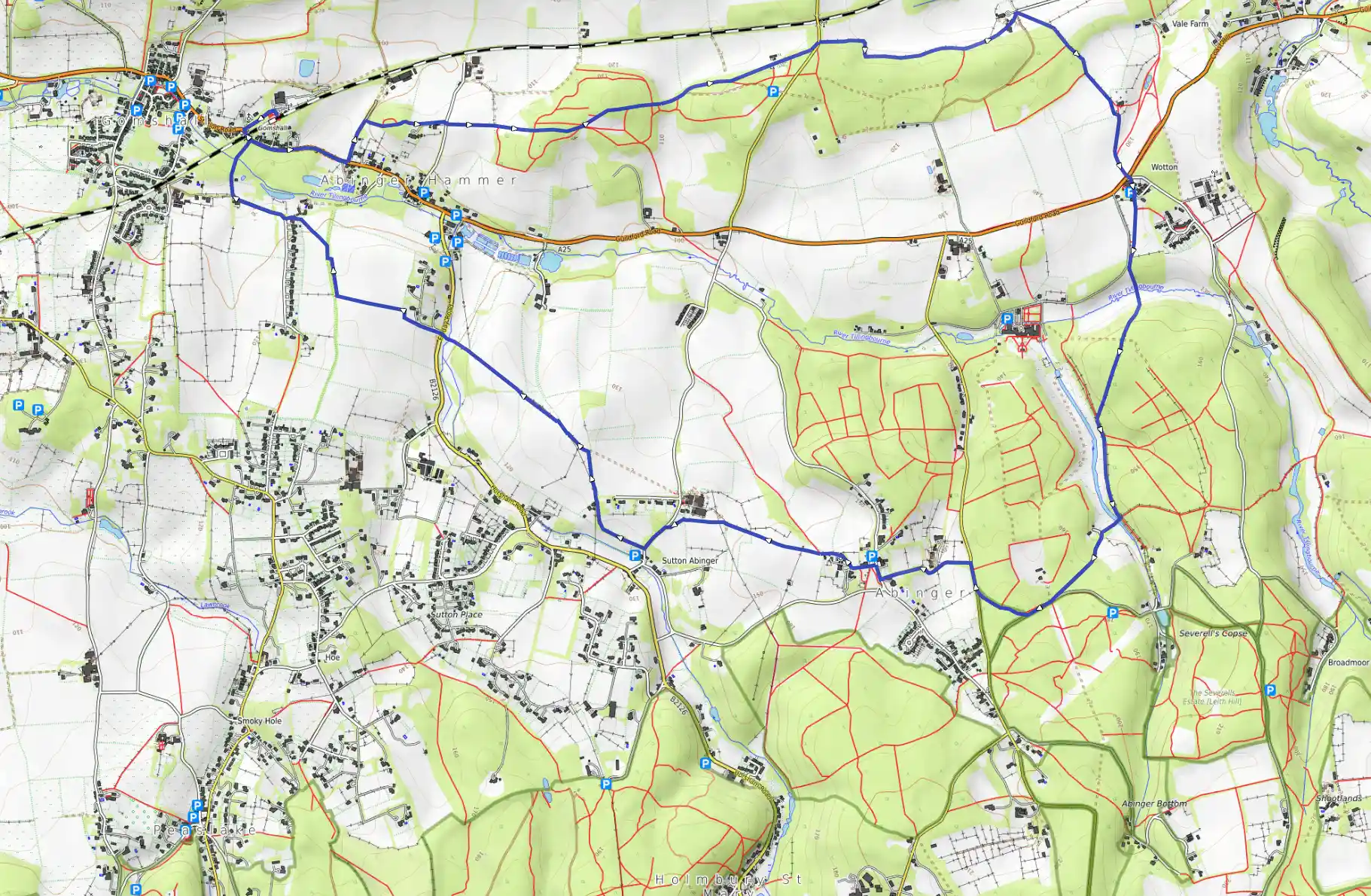
Distance 12.14 km
Est. duration 02h 30m
Elevation Gain 256 m
Elevation Loss 257 m
Category Hiking
Description
Route
Start
Start
51.21966, -0.44191Turn left out of the station and walk through the car park into Station Road and pass under the railway bridge and after 500 yards turn left along an enclosed track (Beggars Lane) at a public byway signpost.
424 m
51.21768, -0.43761
After 200 yards look out for a narrow, uphill path through trees on the right and follow this, through a gate and along an enclosed path with some good views on the left over the valley towards Netley Heath. Cross a lane and pick up the path opposite to go through a gate and then keep ahead on a gradual ascent, following blue waymarkers to enter the woodland of Broomy Downs. At a junction of paths keep ahead along the main bridleway, through an area called Abinger Roughs, following an undulating route through the trees to pass a memorial to Samuel Wilberforce. This marks the spot where the son of the abolitionist was killed after falling from his horse in 1873. At a road cross over and follow the bridleway (not the footpath to the right of it), along an enclosed path with fields to the left.
1.85 km
51.22223, -0.40822
At the junction of paths just past Park Farm bear right uphill along a footpath that goes across grass towards woodland.
2.47 km
51.22344, -0.39592
Go through a kissing-gate into Deerleap Wood and follow the enclosed path past a church, all the way to the A25 at Wotton. The Saxon church stands alone overlooking the North Downs and has some unusual carved heads around the porch door including those of King John and Archbishop Stephan Langton. Inside is the tomb of John Evelyn, the diarist. Cross the road and head through the car park beside The Wotton Hatch pub then climb a stile and make for the top right corner of the field to climb another stile. Follow the sunken path downhill to cross the Tilling Bourne stream and ascend the other side. Go over another stile and follow the path as it heads uphill through Damphurst Wood, ignoring side paths. At a T-junction before a series of weirs, turn left and continue along a wide path and hop over a stile to reach a path crossing.
4.02 km
51.20379, -0.38968
Turn right and cross an old stone bridge over the Tilling Bourne and bear left along an uphill track, to a road. Turn right along the road and look out for where you join a path on the right, beside a sunken bridleway. At a road turn right, and then first left along a tarmac lane. At the T-junction turn right to pass The Abinger Hatch pub, which is in a peaceful spot, opposite the church and the tiny village green. Turn left by a public footpath sign in front of the church, go through the lychgate and pass to the left of the church to go through a gate and along an enclosed path that skirts Abinger Manor and its motte. Go through a kissing-gate and keep ahead, initially along the left edge of a field, after which the path becomes a track and curves left before Raikes Farm. At a fork bear left and continue beside a wire fence along a narrow path. Go down steps and at a lane, turn left. At the end of this lane is The Volunteer, another charming pub with an attractive garden, but to continue the walk, turn right at a bridleway sign before reaching the pub.
5.62 km
51.20267, -0.41916
Follow this as it swings right at a set of iron gates, and continues along the right-hand edge of a field. Cross a track and bear left along the bridleway and at the next three-way signpost, turn left to join a public footpath. Keep beside the wire fence on the left, climb a stile and maintain direction as the path descends across farmland. Climb another stile and continue along a narrow enclosed path to hop over a stile to a road. Cross the road and go over the stile ahead then keep ahead across a field, passing to the left of two large oak trees and, at the field edge, by a public footpath signpost, turn right.
6.79 km
51.21247, -0.43811
The path curves left and passes a stile to reach a bridleway where you turn left, through a hedge gap and head diagonally right to the corner of the field. Bear left along a track and at the T-junction by Southbrook Farmhouse, turn right along a gravel bridleway and follow this as it veers to the right and crosses a stream before reaching the A25. Turn left to go under the railway bridge and return to where the walk began.
12.14 km
Finish