Meon Valley rails and trails
May 16, 2025
Winchester, England, United Kingdom
Easy
Not completed
Description
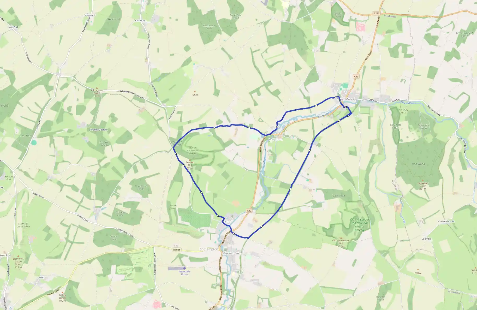
Route
Start
9 m
Start
51.00103, -1.14852With your back to the road, set off along the public footpath that leaves the car park through a gap just to the right of the South Downs Way bridleway track. Follow the signposted heading across the field towards a small clump of young fir trees, then climb the stile in the far hedge and turn left onto the road. Continue 400 yards to a signposted stil on your left.
453 m
A
50.99582, -1.14321Turn left over the stil, then bear gently right, dropping away from the right-hand hedge towards a waymarked stile. Clip the corner of the next field, cross two more stiles and continue over the series of stiles that leads you diagonally through the next five fields to a substantial 'South Downs Way walkers' signpost. Keep ahead here through the gap, then bear left along the left-hand hedge and continue through a kissing-gate to meet Church Lane. Turn right, then left at the T-junction, and walk down to the junction with Shoe Lane. Keep ahead here, cross the river, and stop at the A32. Take care as you cross this busy main road into Stocks Lane, and keep ahead past Rectory Lane until you reach the junction with Shavards Lane.
1.99 km
B
50.98089, -1.12214Turn right here, go under the broken railway bridge, then turn immediately left up the slope to join the former railway line. Cross the South Downs Way at Garden Hill Lane and carry on for 1/2 mile (800m) until you reach the slope down to Peake New Road.
3.10 km
C
50.99289, -1.10622Cross over by the missing bridge, keep ahead up the slope, and continue walking along the old railway. The line dives into a cutting as you approach Hayden Farm, where Old Winchester Hill Lane soars overhead on a massive masonry arch. The line escapes briefly from the cutting to steal across the track from Brocklands Farm before entering the site of West Meon station.
4.49 km
D
51.00810, -1.08704Fork right here to explore the old platforms and the towering embankment that once carried trains onto the 62-feet (19m) high steel viaduct that was demolished soon after the line was closed. Otherwise, walk through the parking area and fork left down the old station approach towards West Meon. Turn left at the junction with Station Road and drop down to the village and A32. You can turn right here for a break at the Thomas Lord (The pub is named after the founder of Lord's cricket ground, who is buries in the churchyard). To continue the walk, zigzag left and right across the A32, watching carefully for traffic on this awkward bend. Join the signposted footpath beside 'Warnford Corner cottage, cross a drive and continue into the churchyard. The church was designed by Sir Gilbert Scott and consecrated in 1846. Halfway along the gravel path to the church, turn left between the gravestones to a stone-built stile in the churchyard wall. Nip across, and follow the enclosed path out past the large converted barn houses and cross the access road into the field ahead. Keep ahead, following the hedge line on your right and keeping parallel with the A32 in the valley on your left. Go through a gap in the hedge at the end of the field, cross a stile, and continue beside the right-hand hedge to a stil leading out onto Lippen Lane near Beaconsfield Farm.
5.84 km
E
51.00913, -1.10846Turn left, and follow this winding lane past the houses and back to the A32. Turn right briefly along the road-side pavement, pass Rose Lea Cottage, and take the next turning right on to Wheely Down Road. Pass the Wheel Horse on your left, and continue to the farm entrance just before Wheely Down Forge.
6.96 km
F
51.00633, -1.12792Turn left onto the signposted bridleway (waymarked The Monarch's Way) and bear right past the farm buildings to begin the climb back to Beaconhill Beeches. Soon the signposted bridleway leaves the farm track through a metal gate on your right, turning immediately left to follow the left-hand field edge. Go through the gate at the far corner of this narrowing field and walk along the enclosed bridleway before continuing beside the wire fence on your left for 220 yards. At the end of the fence the waymarked path bears left along an unfenced grassy track that leads to wooden gates at the entrance to Beconhill Beeches. Keep ahead through the gate, now following the well-made gravel track that makes light work of the short woodland walk back to your car.
12.88 km
Finish