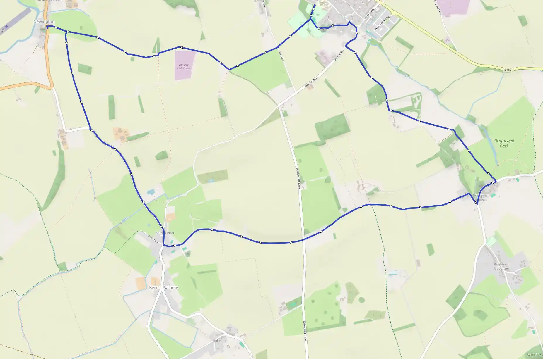
Description
Route
Start
Walk down the western side of the recreation area, passing to the right of the children's play area. Keep right along an obvious path between a fence on the left and trees on the right. After a bridge, keep straight ahead through the middle of the playing field. Beyond the gap in the hedge on the far side, continue along the field edge. Go straight over at a minor road. When the fenced section of path ends, stay with the power lines until meeting some trees at the top of the next field
703 m
Don't go through the gap in the trees here; instead, turn right to walk with the field boundary on the left. The line taken along this field edge leads naturally through an arched gap in some trees. Go straight over a farm track to walk with a solar farm on the left-hand side. On the far side of this, look for a line of hedgerow slightly ahead and to the right. Stroll over to this and then walk with it on the right. The vague track underfoot splits at the far end of this short stretch of hedgerow. Bear left. About 500 yards beyond the solar farm, there is a temptation to swing left with a rough track, but maintain the now pathless line, walking with a field boundary on the left.
1.42 km
Pass through the hedgerow and continue along the field edge. About 70 yards after the field boundary bends slightly right, go through an easy-to-miss gap in the vegetation on the left. A trail leads through this uncultivated area. Cross a bridge and stile, and head west-north-west on a line through the grass. This leads to a stile.
1.81 km
The route returns to this point after visiting Newington, which is home to the pretty church of St Giles and a 17th-century manor house. Cross this stile and a second one. Aim for the houses below, cross the stile in front of them and then follow the path to the A329. The church and manor are to the left. Having explored, return to the pair of stiles at C. After crossing, turn right and negotiate yet another stile. There is little to guide the way across the next area of farmland. The right-of-way goes south-south-east initially, heading towards a small copse. There is no way through the trees, so keep to the western (right-hand) edge of them. There's a grassy track here that then passes through the middle of the crops. When it later bends left, leave it by continuing roughly south. Aim to the right of a power pole almost halfway between Lane End Farm and Ewe Farm. Just beyond this, there is a trail through the vegetation at the field edge. It's not easy to spot. Turn left along the road.
2.74 km
In Berrick Prior, take the lane on the left just before The Chequers Inn. At a sharp bend to the right, follow the bridleway straight ahead - signed to Brightwell Baldwin.
3.81 km
Go straight across at a road to continue on the bridleway. Later emerging in a field, walk with the hedgerow on the left. At a crossing of routes, keep straight on - along a rough track. On the far side of the field, keep left. Leave this broad track when it bends left. Keep straight on here, through a gate. After the next gate, walk with the fence on the right. A further gate gives access to another fenced section of bridleway. This leads to a lane on the edge of Brightwell Baldwin.
5.83 km
Turn right here and go left at the road. The route now passes the church, surprisingly large for such a small village, and the Lord Nelson pub. Drawing level with thatched Glebe Farm on the right, cross the stile on the left, joining Shakespeare's Way. The path stays close to the fence on the left as it makes its way along the edge of Brightwell Park's unkempt parkland. (The unusual building on the right in a short while is a dovecote.) After another two stiles, cross a track and then follow the trail cut through the crops ahead. Beyond the next stile, aim for the large gate some way to the right of Cadwell Farm. Cross the stile next to this. The trail through the trees leads to a grassy track. Bear left here and quickly turn right along the surfaced farm lane.
6.97 km
Later, turn right at the road. Follow it round to the left and go left at the T-junction - along High Street. Turn left again along Church Lane. The road bends right near a thatched cottage. Take the track on the left here - towards the church. Passing to the right of the church, ignore a trail heading into a residential area; keep straight on to locate a path leading back to the recreation area. Pass to the left of a tennis court and five-a-side pitch and then see, to the left, the path taken earlier. Ignoring this, keep straight on - with the play area over on the right - to return to the car park.
12.97 km
Finish