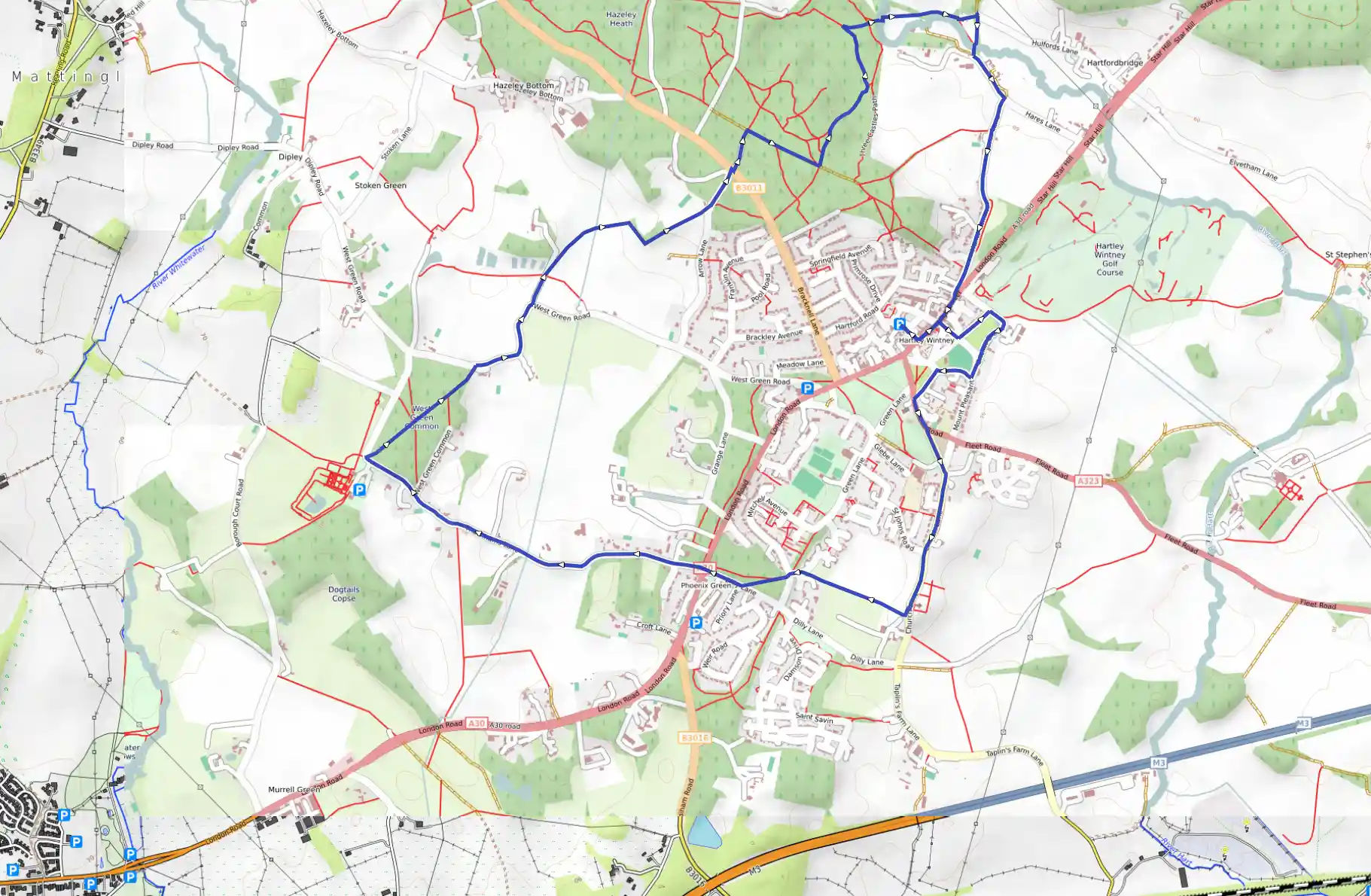
Hartley Wintney, Walk through the Past
May 19, 2025
Hart, England, United Kingdom
Easy
Description
Route
Start
58 m
From the centre of the village cross the pelican crossing and turn left. After 100m take the first right into Hardings Lane, and turn left following the road clockwise around Causeway Common and Cricket Green.
462 m
Turn left up Cricket Green Lane and cross the A323 at the crossing. Turn right then left into Green Lane until you reach the footpath on the left leading past St John’s Church.
697 m
Continue along this path to a drive leading to Oakwood School. Cross over the drive passing the pond on your right and continue to a kissing gate in the corner of the field on the opposite side of the road.
757 m
Continue along the footpath that is parallel to the road until you reach St Mary’s Church. Continue down the steps turning right through the gate to the Burial Ground, turn left through the lychgate passing the entrance to St Mary’s Church.
1.20 km
Immediately turn right to the road. Cross the road to the footpath and follow the path downhill to Mitchell Avenue. Cross the road and pass on through the woodland. The footpath divides at a fork, take the left hand path which leads to Dilly Lane.
1.66 km
Turn right to the main road (A30), cross over and continue along Thackham’s Lane. Continue to the woods at West Green Common. Turn right by West Green House, into West Green Road. Continue right along the road. After a couple of bends, turn left up the drive taking the second kissing gate on the right. Turn left at the stile. The 18th century Hazeley House is visible on your left as you continue through the kissing gate onto Arrow Lane. Turn left at the lane to the main road (B3011), cross over the road through the gap in the bund onto a concrete track on Hazeley Heath. Continue for 100m then turn right along a broad track through a plateau of grassland.
3.96 km
Turn left along a concrete track, to concrete structures (these were used for training WWII troops on how to extract bogged tanks), follow the route down the slope onto the heathland. Continue along the track until it branches, taking the left hand branch and across two boardwalks. Just before you get to the telegraph pole turn right into the woodland by the River Hart, continue over the bridge and on through the rough field.
4.87 km
Continue through the kissing gate, keeping the hedge on your right through a further two kissing gates, over a small bridge that brings you to a paddock. Turn right along the river and pass through a five-barred gate and on through a second small gate. Recross the river by the bridge to emerge onto Springwell Lane opposite the amenity site. Turn left along the road and the forest then right into a dead-end lane.
5.25 km
Pass the farmhouse of Hares Farm on the right and continue through the pedestrian pinch point to enter the village by Hunt’s Common. Continue on to the main road (A30), and return along the High Street and the start of the walk.
9.58 km
Finish