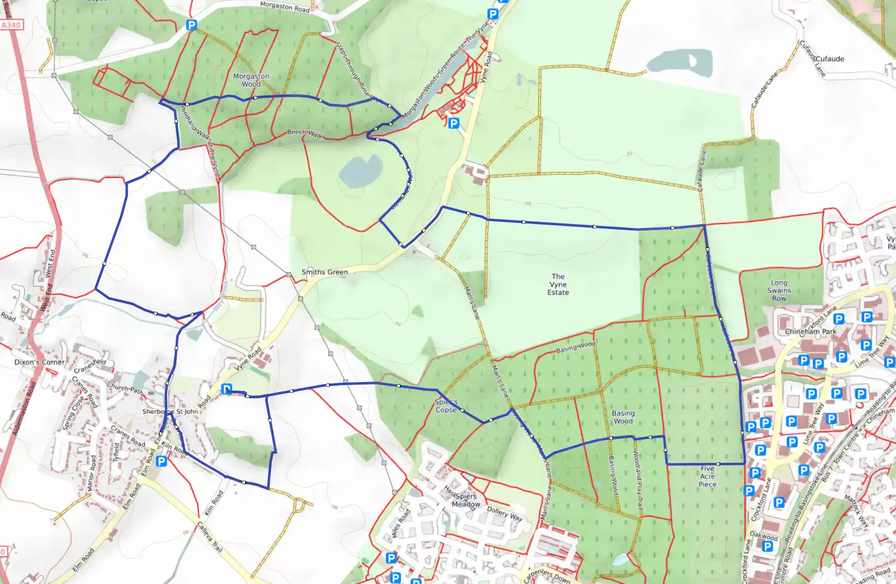
Woods and farmland. The Vyne (National Trust) can be visited. The route uses National Trust paths, one boggy.
Sherborne St John and The Vyne
January 16, 2026
Basingstoke and Deane, England, United Kingdom
Easy
Not completed
Distance 10.27 km
Est. duration 01h 40m
Elevation Gain 79 m
Elevation Loss 82 m
Category Hiking
Description
Route
Start
6 m
51.29590, -1.10233
At Sherborne St John, go along the right edge of the recreation ground. Bear right 50m before the end, down the path to the fields (200m). Go right up the edge of the first field, over the rise, and down beside the wood to the track from Kiln Farm (400m).
386 m
51.29214, -1.09978
Turn right, away from the farm (200m) and stay ahead along Kiln Road (200m). Before the Swan, turn right up Dark Lane (200m).
642 m
51.29354, -1.10491
At the top, cross to the corner (25m) and go left and right to the church door (120m). Turn right along the wall of the church and the path through the trees (60m). At the drive go left, past houses (80m). Keep on between fields, through trees, over the Wey Brook (250m) and into the field (70m).
1.06 km
51.29889, -1.10410
At the right corner, turn left along the top of the field (100m) and continue along the next field below the hedge (350m).
1.39 km
51.29990, -1.11047
Follow the hedge round the bend right, down to the stream (500m) and right to the wood (270m). Turn left up the edge of the trees to the path over the footbridge right (200m).
2.02 km
51.30724, -1.10627
Cross and turn right on the path inside the edger of the wood. Keep on through the wood, disregarding all side paths (500m). Stay ahead on the short stretch of drive and continue to the field (450m). At the edge, see The Vyne half-right. The National Trust car park is 800m along this path.
2.61 km
51.30728, -1.09311
Walk down the path outside the field (150m) and right round the corner of the wood. After the lake (100m) watch out for the ramp down left and go out to the field (20m). (If it's boggy, take the next path left.) Bear left across the field to the farm bridge (200m). In the next field turn right and skirt the trees to the uphill hedge (200m). In the next, cross halfway (100m) then turn left up to the road (160m). Walk up the road left.
3.25 km
51.30157, -1.09125
Pass the left house, South Lodge (220m). After it (30m) find the path right in the trees. Follow the hedge away from the road to the wood (850m). Carry on in the left field to the track after the wood (300m).
4.12 km
51.30226, -1.07258
Turn right and follow the track at the edge of the wood to Chineham Business Park left (500m). Go on under trees to the tarmac side path left from the buildings (300m).
4.78 km
51.29315, -1.07007
After the tarmac side path left (100m), opposite an oblique office block, turn right on the side path across the wood to the T-junction (350m). Turn right (100m) then left on the large path (100m). Stay ahead at the dog-leg bend (100m) then over a hard track and other paths to the end of the wood (300m).
5.40 km
51.29332, -1.08237
Turn right outside or inside the field to the end of the field (200m) and go on to the wide cross track (60m). Turn left. At the left curve (150m), bear right on the side path. Disregarding side tracks, keep on to the fields (500m). Go straight down (300m) towards the rising field boundary 100m left of the farm on the other side of the valley.
6.15 km
51.29596, -1.09711
From the valley go up right of the fence to the hedge on the brow (200m). Slightly left ascend between hedges to the recreation ground and car park (200m).
10.27 km
Finish