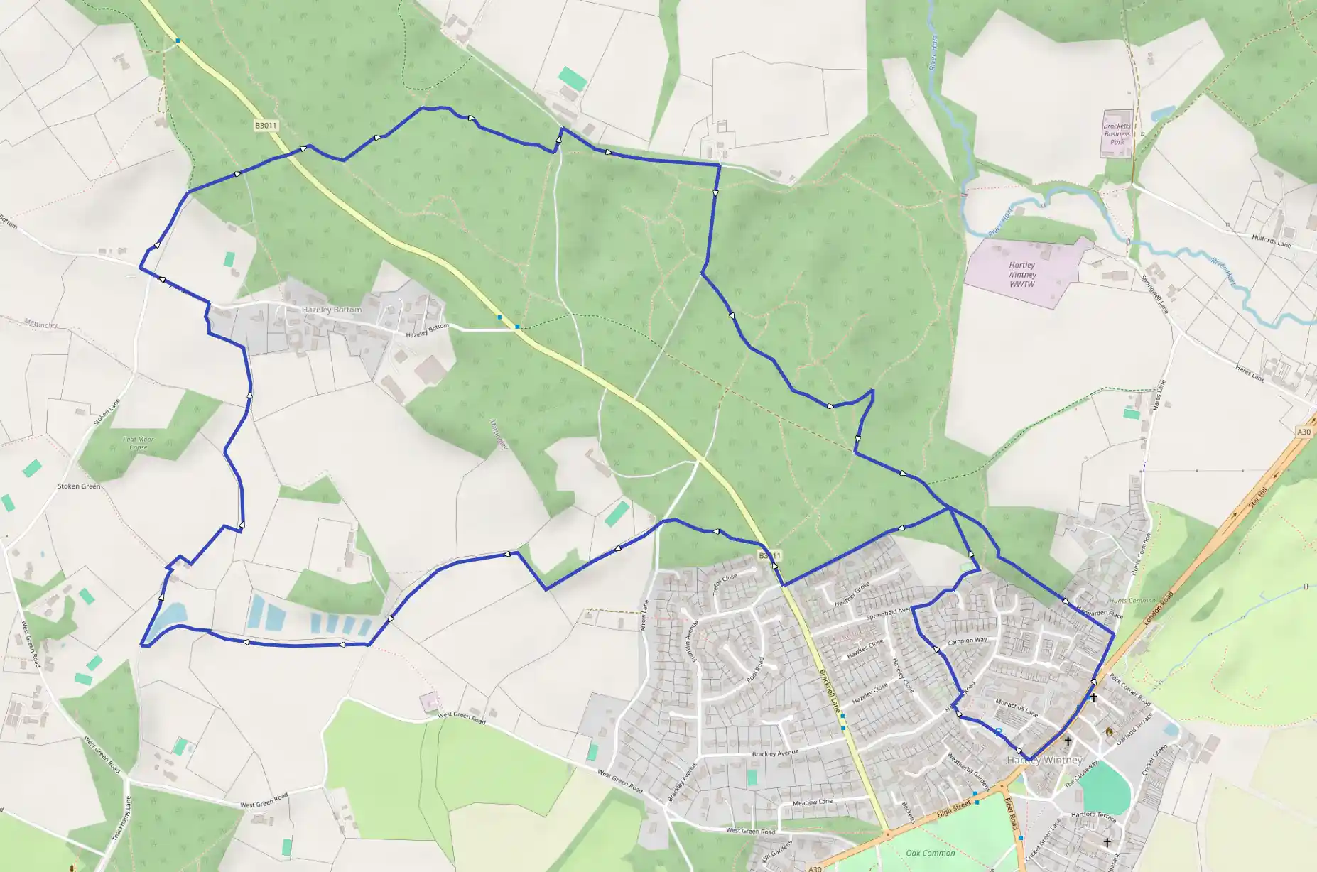
Hartley Wintney and Hazeley Heath
May 19, 2025
Hart, England, United Kingdom
Easy
Description
Route
Start
Start by walking north from the car park away from the village centre, up Chapter Terrace, heading uphill slightly. Turn right onto Hartford Road, and immediately left onto Primrose Drive. Turn right onto Springfield Avenue, and left up a concrete driveway just before a bend in the road, leading to a children's play area. Pass behind the play area and continue uphill on a narrow pathway leading into birch woodlands. On reaching a T-junction with a wider footpath, turn left, and immediately left again along a wooded gravelled footpath, signposted as a public right of way. Continue straight on, following a line of large mature trees and holly bushes on the left-hand side. On reaching a cluster of dwellings, continue straight on between two sculpted posts. The path becomes a wider vehicle driveway for the houses at this point.
673 m
Cross over the B3011, taking care. Turn right along the pavement, and after a few metres look out for a footpath sign on the left, leading into a heathy common. Take the left-hand fork of two grassy paths to a quiet road. Cross to a white cottage directly opposite, and turn left along a farm track. Look out for a footpath sign in the hedge on the right and pass into a horse-pasture field. Keeping the field boundary close to your right, continue straight on downhill to the bottom of the field. Cross a stile and turn right then pass into a second field. Turn left, skirting the field boundary, and continue to the far end of the field, past a single house on the right. Pass through the hedge via a small footbridge into a meadow and continue straight on. Pass through a kissing gate on the right-hand side.
1.38 km
Turn left along the driveway to Inholmes Court and immediately right through a kissing gate in the hedge into an arable field. Keep the field boundary close on your right-hand side, and continue straight on. At the end of the field, pass through a gap in the hedge on the right, cross a ditch via a small footbridge and turn left passing a lake and views of Sherwoods Farm. On reaching a driveway, turn right and walk towards the farm, passing to the left of the farm.
1.82 km
Just before the outbuildings, turn through a gap in the hedge on your left. Turn right in the field, right again, keeping to the field edge, and continue straight on towards the hamlet of Hazeley Bottom. Three quarters of the way down the field, cross a stile on your right, then pass through double gates and turn left. Keep the ditch and hedge close on the left-hand side. Cross a stile and after 25m or so, turn right across the field, crossing a ditch and a further stile. Continue straight on between fields. The path then skirts the gardens of Hazeley Bottom, turning left then right and leading to a small set of steps down onto a rural road.
2.33 km
Turn left away from the hamlet. Opposite Stoken Lane, turn right onto a footpath between fields. After 200m or so, turn right away from the sunken lane up a slight incline into woodland. Follow this path to a driveway and turn left along it. Take care at the B3011, crossing to a narrow footpath directly opposite into woodland. After a few metres, on reaching a T-junction of paths at the edge of the heathland, turn right and continue for around 70m to a distinct crossing of paths in a slight dip in the landscape. Turn left here, crossing the heath. At a further T-junction of paths, turn right, and continue straight along this pathway to a driveway. Turn left here, then right along a wooded footpath, skirting the edge of the property. Continue straight on to Purdies Farm.
3.39 km
Turn right along the wooded driveway back across the heath. After 250m or so, turn left past two bollards and follow the grassy footpath into the heathland. At a fork in the grassy paths, take the right-hand fork. Cross over an intersecting grassy path and continue straight on. At a second intersection of paths, continue straight on. At a further fork of paths, turn left, emerging at a concrete pathway and the remnants of a tank trap. The ramp was used for tank evaluation and testing the breaking strains of steel cables during WWI and II. Troops were also trained in tank rescue from boggy ground on the heath.
3.86 km
Turn right along the concrete path and left along a wide gravelled path. Pass a footpath sign on the left, and a bridleway sign on the left. Continue into woodland. The path turns slightly to the left with a large wooded field bank on the right-hand side. Follow the pathway downhill to a kissing gate, then pass between houses and a play area. Turn right along Hare's Lane back into Hartley Wintney and turn right along Monachus Lane or between shops further up the high street to the car park.
7.56 km
Finish