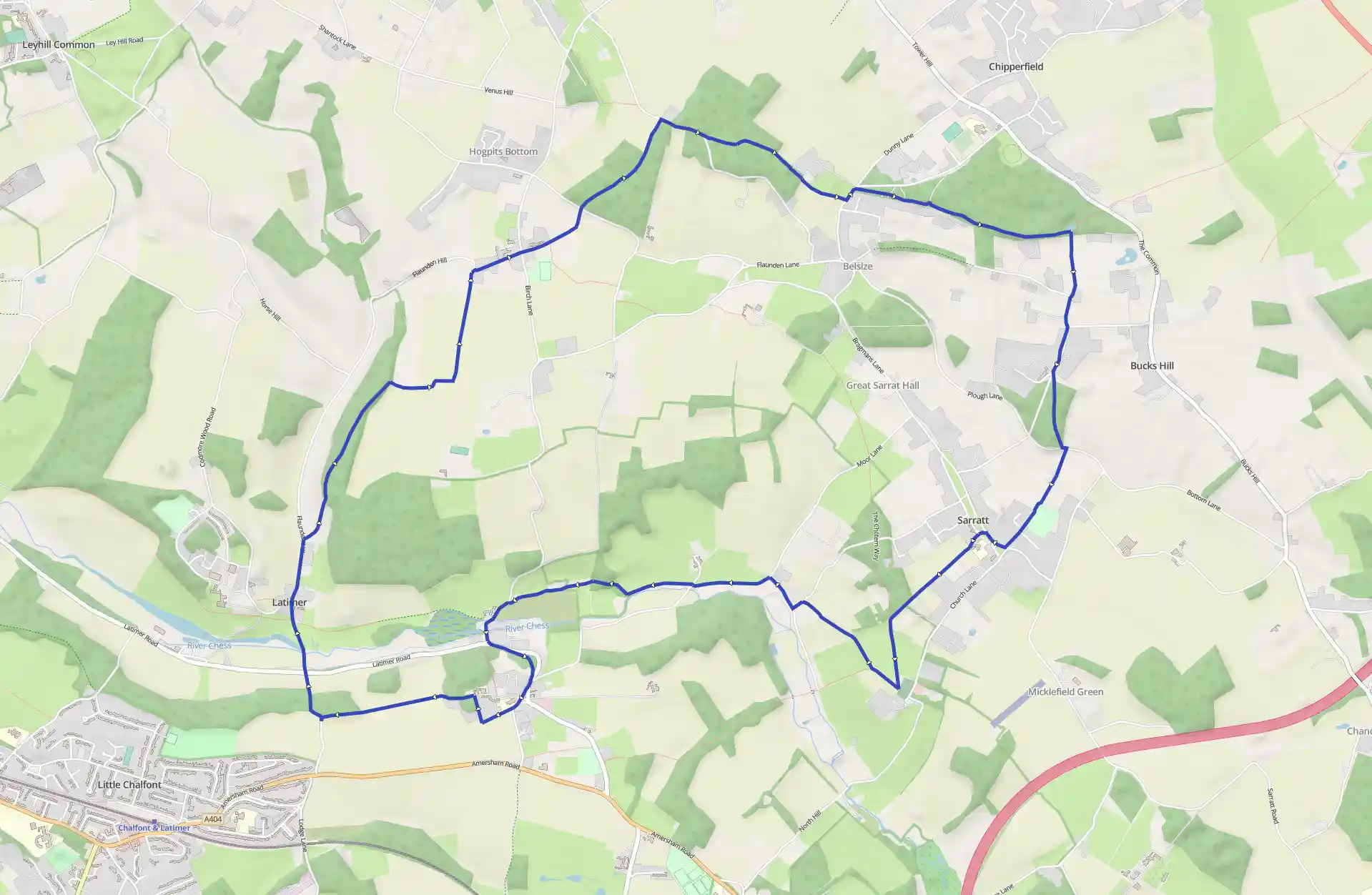
The Chess is one of a number of small rivers that rise in the Chilterns and flow south-eastwards into the Thames Basin. This walk explores a particularly attractive part of the Chess valley, linking a series of villages - Latimer, Flaunden and Sarratt - lying to the north of the river, and one, C
Chess Valley
August 18, 2025
Little Chalfont, England, United Kingdom
Moderate
Not completed
Distance 15.23 km
Est. duration 03h 03m
Elevation Gain 221 m
Elevation Loss 219 m
Category Hiking
Description
Route
Start
7 m
Start
51.67344, -0.54745From the parking area turn left downhill along the road to a crossroads and keep ahead, in the Latimer and Flaunden direction, to cross the River Chess into Latimer, a small, pleasant village with an attractive green. Continue through the village and where the road curves slightly left, turn right on to a public bridleway (signposted Flaunden) enclosed by wire fences.
679 m
51.68265, -0.54868
The bridleway soon turns left and heads uphill to enter Long Wood. At an immediate junction keep left, continue through this attractive woodland and on reaching its right-hand edge, turn right to walk along a narrow, hedge-lined path, later continuing along a track to a T-junction of tracks. Turn left and follow a straight, broad, hedge-lined track into Flaunden; the track curves right to reach a road just to the right of the Victorian church.
1.98 km
51.69641, -0.53461
Keep ahead to walk through the village passing The Green Dragon pub and at a crossroads keep ahead again along a lane signposted to Belsize and Watford, which curves left to a T-junction.
2.45 km
51.69963, -0.52595
Go through the gate opposite, at a public footpath sign, and follow a path through the woodland of Lower Plantation, then continue along the left inside edge of the wood to go through a gate on to a lane. Turn right along the lane for 1/4 mile (400m) through Woodman's Wood and, where it bends right, keep ahead by a barrier, at a public footpath sign to Belsize, to continue along a path through the wood.
3.05 km
51.70333, -0.51591
Follow the main path all the while, crossing over a path by a waymark post to continue along the left inside edge of the wood. After emerging from the trees keep along the left-hand edge of a field, by a hedge on the left, heading down to a gate on to a road at Belsize. Turn left, take the first turning on the right and immediately turn right E, at a bridleway sign, on to a path that heads uphill between trees and bushes.
3.63 km
51.70021, -0.50391
Cross several drives and continue along wide tracks and paths on the southern edge of the thickly wooded Chipperfield Common as far as Apostle's Pond, a small pool just to the left of the path where there is a bench. This is an exceptionally beautiful part of the walk and the route is well- waymarked with blue arrows.
4.49 km
51.69842, -0.48534
By the pond turn right over a stile and walk along a path between a hedge on the left and a wire fence on the right. Continue between wire fences, bearing right to go through a metal kissing-gate at a corner of a lane. Keep ahead along the lane to the Cart and Horses at Commonwood, bear slightly right to continue along the lane.
5.04 km
51.69089, -0.48645
At a fork take the left-hand lane which descends through woodland to a T-junction. Turn left, then at a public footpath sign turn right over a stile.
5.28 km
51.68744, -0.48595
Walk along the left-hand edge of a field, by a fence and hedge on the left, heading up to a gate in the corner. Keep along the enclosed path. When it splits, keep right, pass between paddocks and tennis courts and then continue beside wooden panel fencing to the road. Keep ahead to a crossroads in Sarratt, a pleasant, spacious village with houses, cottages and two pubs grouped around a long green. The church, passed later on the walk, is 3/4 mile (1.2km) away at Church End. Turn right along The Green, passing The Cricketers and the village duck pond, and at a public footpath sign to Church End turn left along a track.
5.80 km
51.68298, -0.49229
Go through a gate and continue along the left-hand edge of several fields to enter woodland. Continue through the trees, later keeping by a wire fence on the left, and head down to a track. Bear left, negotiate a metal kissing-gate and a stile, and follow a path along the left-hand edge of a field, by trees on the left. Where the trees end, continue across the field - there is no visible path - making for the tower of Sarratt church just beyond the field corner. The church is mainly Norman, enlarged over succeeding centuries, and nearby are a pub and some early 19th-century almshouses.
6.52 km
51.67504, -0.49954
Do not climb the stile in the field corner but turn sharp right in front of it to keep along the left-hand edge of the field, by a hedge on the left, to a stile. Climb it and ahead is a superb view over the Chess valley. Continue downhill along a tree-lined track, and at the bottom walk across a field, making for a stile in the hedge on the far side Climb the stile and keep ahead, by a hedge and wire fence on the left, to go through a gate and descend steps on to a narrow lane. Turn left to Sarratt Bottom and at a T-junction turn right. Where the lane bends right, turn left, at public footpath and Chess Valley Walk signs, through a metal gate.
7.17 km
51.68070, -0.51021
A quiet and pleasant section follows, through the Chess valley with the river to the left. Walk along a concrete drive and at the end of it bear slightly right to follow several stretches of boardwalk. Continue across meadowland by the river, following Chess Valley Walk waymarks, passing through a small area of woodland and finally reaching a lane. Bear left along the lane, cross the river and at a fork bear left up to a road.
8.32 km
51.67747, -0.53346
Turn left and then go up steps, and continue along a shady uphill path, parallel to the road, which curves right to rejoin the road. Continue uphill into the village of Chenies, where church and manor house stand side by side in traditional fashion. The red-brick Tudor manor house belonged to the Russell family, dukes of Bedford, and inside the restored, mainly 15th-century church are several impressive Russell family monuments. Among those buried here is the Victorian Prime Minister, Lord John Russell. Keep along the right-hand side of the triangular green and where the road bends left by a school, keep ahead, at a public bridleway sign, along a broad track. At a T-junction turn right and, opposite a concrete track on the right leading to Chenies Manor, turn left through a metal gate along a broad, tree-lined track. Go through another metal gate and follow an attractive path which runs along the side of the Chess valley, between scrub and bushes on the left and a wire fence on the right, with superb views to the right over the valley and Latimer village. The path enters woodland and emerges on to the road opposite the parking area.
15.23 km
Finish