Description

No description for now...
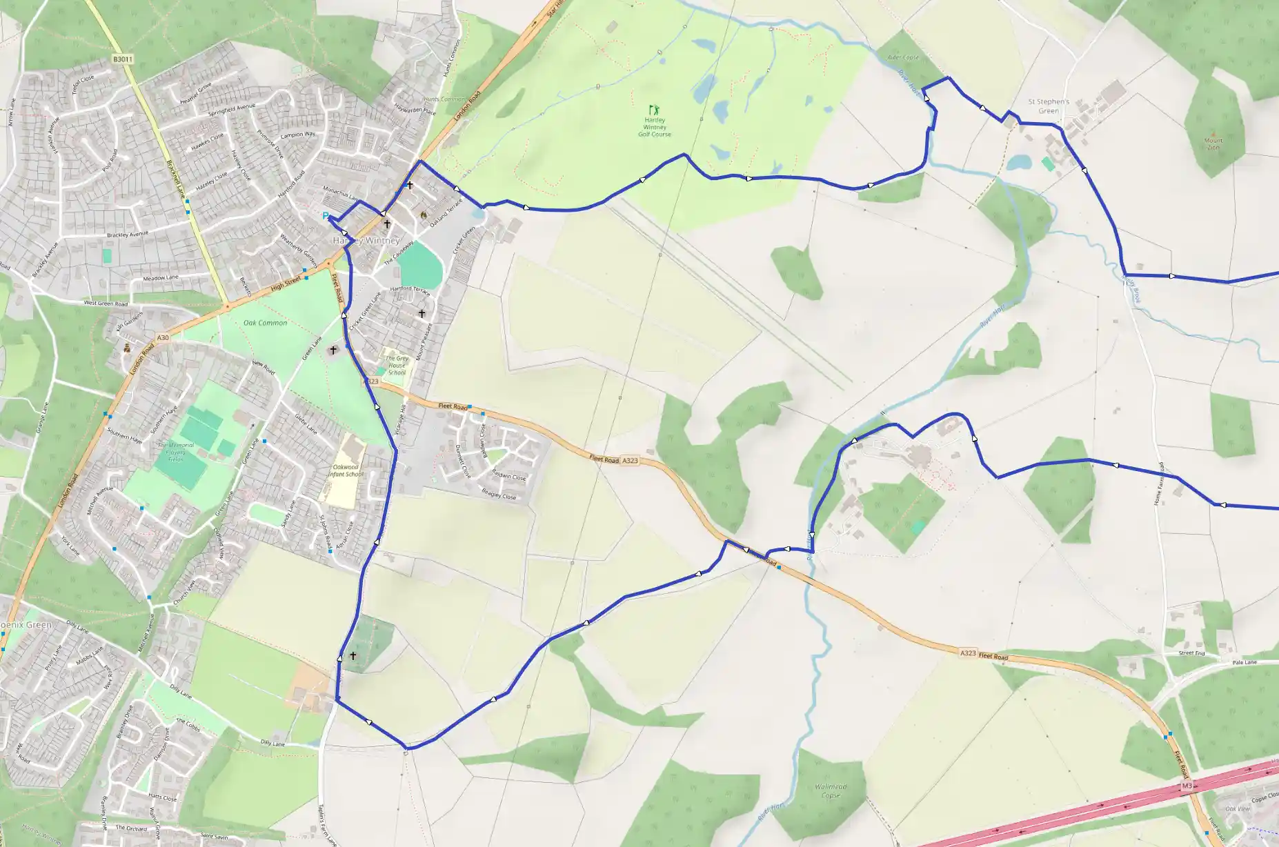
Route
Start
5 m
Start
51.30670, -0.90092Take either of the exits from the car park to the High Street and cross to the pavement opposite. Turn left and walk to the last house before the Golf Course and take road to the right as far as the Duck Pond - Causeway Pond. The farmhouse beyond is Causeway Farm. There is a stile and footpath sign on the left side of the road as it passes the pond. Follow the footpath that goes along the edge of the Golf Course. Initially bear right towards the corner of the perimeter hedge of the garden of Causeway Farm and then keep close to the hedge and the perimeter fence of the Golf Course as far as the post with sign to Elvetham.
668 m
Follow the direction of the sign, turning right from the Golf Course to where, within a few yards, the path joins a wide cart track. Turn right along the track under the wires of a pylon and through the new part of the Golf Course. Though the waymarks should show the direction line of the path you should, on reaching open fields beyond the Golf Course keep to the left of the hedge i.e. right hand edge of the field. In the distance - half left - are the buildings of Horne Farm to which the path leads. Along the path there is a stile - later a six bar gate and a cattle trough. After this it follows the bank of the River Hart for about 100 yards, to a concrete footbridge taking the path across the river, then the path turns left, right, and right again turning in the direction of one Home Farm's outbuildings. Just before the building the path bends left and joins a track to the right that passes farm cottages to Elvetham Lane. On reaching the lane, turn right and walk about 500 yards past Home Farm on the right towards Baker's Bridge.
1.71 km
There is a footpath sign by the cottage on the left-hand side of the road just before reaching Baker's Bridge. Follow this path; it ascends and keeps to the right hand edge of three fields with the hedge to the right of it. In the third field and at the point where path reaches woodland at the corner of the field, it leaves the field across a footbridge to the right and follows the edge of the woodland for about 30 yards and then turns left. Follow the path between the woodland and the barbed wire fence as far as a barn on the site of what on the map is shown as Word Hill Farm. Just beyond the barn is a track.
2.47 km
Turn right along the track in the direction of Turner's Green Farm. About 300 yards ahead there is a wooden bridge over Fleet Brook beyond which the path leads towards the house and outbuildings which comprise Turner's Green Farm. The track joins a metalled road before reaching the farm. Follow this to the right and look out for a footpath sign on the right about 500 yards along the road and follow the path towards a dead tree, with a few branches, standing in the hedge on the horizon on the far side of the field. Turn right along the track in the field. On reaching this landmark follow the path across the next field towards the near right hand corner of the perimeter hedge of the house there - The Old Rectory. On reaching the hedge, follow the path along the line of the hedge to the right of the property as far as the road.
3.30 km
To reach the church cross the road to the footpath sign opposite the entrance to The Old Rectory. The footpath crosses the field to a plantation of conifers - head for the lefthand comer of the taller trees to the right of the plantation. After the stile follow the path through the plantation as far as another stile. Although the church is now in sight, the path to it is unclear. Follow a direction in line with the lower step of the stile across some open ground to a stile beyond which is the farm road leading towards the church. From there the way to the church is clear. The Conference Centre that now owns Elvetham Hall now uses the church as a lecture room. However, the Chairman of Hartley Wintney and Elvetham Parish Councils, lays a wreath on the War Memorial each year on Remembrance Day. From the front of the church there is a good view of Elvetham Hall.
3.64 km
Continue from the church along the road through the grounds of Elvetham Hall to the main entrance. Permission to do this may be sought by making a telephone call before starting the walk to the Management of the Conference Centre (01252 844871). Sympathetic responses have been given. Having reached the Fleet Road entrance to the Conference Centre, turn right and almost immediately cross the road to where a footpath sign points the way through a coppice. On the other side of the coppice, take the path along the left-hand side of the field. This follows the line of the hedge as far as the house - Shepherds Cottage. Here the path joins a farm track up a gentle slope and then gently down and then a bend to the right.
4.51 km
Where the end of the track and a road come in to view and the track passes under telegraph lines, there is a path to the right through a gap in a hedge. Go up and across the field towards a house - Church House Farm. There is a stile and gate at the far side of the field opposite the farm. On the side of the stile the footpath turns right and climbs uphill through the trees parallel to the road as far as the perimeter fence of the churchyard. Enter the churchyard and take the path past the front of the church to the Lychgate. Go through the Lychgate to a lay-by at the other end of which, the path resumes through a gate to the burial ground. Immediately going through the gate turn left up steps towards the hedge where through a stile the path enters a field. Follow the hedge parallel to and immediately above the road to the left. The path will go across the entrance to a house, through some trees to a second field and on to the far side of this there is a stile before it ends at the road. Cross the road to the pavement and turning right, follow the pavement until it joins the common just by the entrance to Oakwood School.
5.40 km
To return to the car park, follow the path parallel to the road in the direction of St John's Church. On reaching the church, cross the road and, turning left, follow the opposite pavement as far as Cricket Green Lane and take the footpath that crosses diagonally the next piece of common to the road alongside Hatton's Pond. This leads to the High Street and the pedestrian crossing beyond which, to the right, is the pedestrian road to the car park.
9.27 km
Finish